
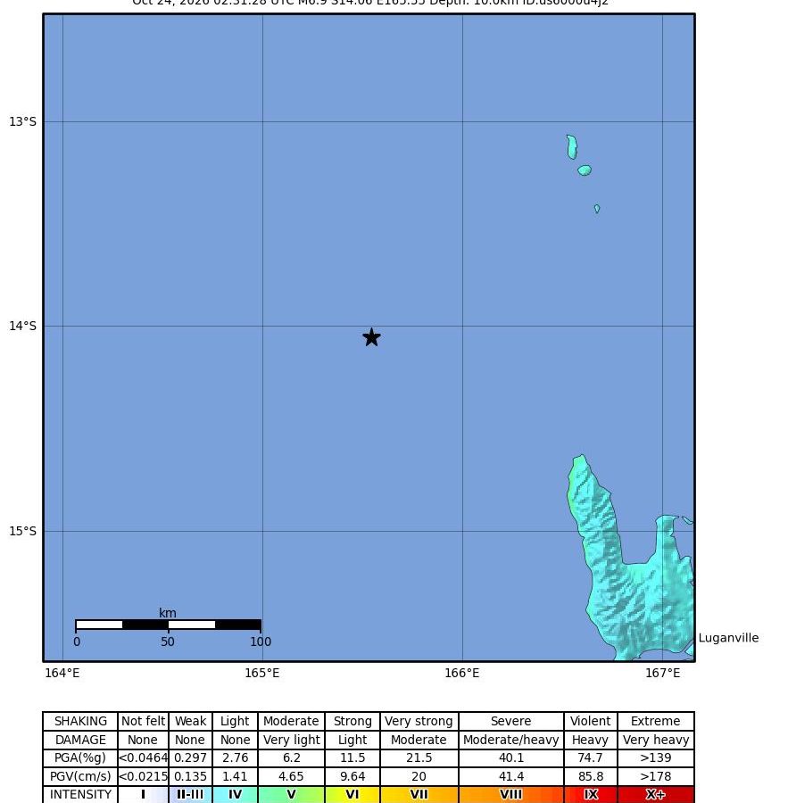
The USGS puts the Vanuatu earthquake at magnitude 6.9, revised down from a preliminary 7.2, at 02:31 UTC on Oct. 24, about 10 km deep. The Pacific Tsunami Warning Center issued a threat message, then said at 03:28 UTC the threat had passed. No immediate damage reports.
In this article
A magnitude 6.9 earthquake struck in the sea off northern Vanuatu at 02:31 UTC on Saturday, Oct. 24 (Friday evening, Oct. 23, in the United States), according to the U.S. Geological Survey (USGS). Tsunami warning centers first reported the quake as magnitude 7.2, and the Pacific Tsunami Warning Center (PTWC) issued a threat message for nearby coasts. About an hour later the PTWC said the threat had passed. The Associated Press reported no immediate reports of damage.
What happened
The USGS located the earthquake 197 kilometers west-northwest of Port-Olry at a depth of 10 kilometers. New Zealand’s 1News described the epicenter as about 200 kilometers west of Sola, in the Banks Islands at the northern tip of the archipelago, and northwest of Espiritu Santo.
A second strong earthquake followed four minutes later. The USGS lists a magnitude 6.3 at 02:35 UTC, about 170 kilometers northwest of Port-Olry. Depth estimates for the main shock differ by agency: according to The Watchers, which cited the Vanuatu Meteorology and Geo-Hazards Department (VMGD) and the European-Mediterranean Seismological Centre, the figures are 20 kilometers and 8 kilometers, against the USGS’s 10 kilometers. 1News described it as a shallow earthquake.
Why the magnitude changed from 7.2 to 6.9
The first figure was a rapid estimate. The PTWC’s first message, at 02:37 UTC, gave a preliminary magnitude of 7.2. Its second and final message, at 03:28 UTC, carried the note “revised magnitude” and gave 6.9. The USGS’s reviewed solution (magnitude type mww) is also 6.9. AFP reported that the USGS “later revised” the figure down to 6.9.
Some outlets published the 7.2 figure before the revision, and a few headlines still carry it. We use the USGS figure, 6.9, throughout this article.
Was there a tsunami?
The PTWC’s first message said hazardous tsunami waves were possible for coasts within 300 kilometers of the epicenter, and listed only Vanuatu as threatened. It gave a modeled arrival time of 03:01 UTC for Espiritu Santo, an estimate and not an observation of a wave.
At 03:28 UTC the PTWC said, based on all available data, that the threat from this earthquake had passed and that there was no longer a tsunami threat. It added that minor sea level fluctuations might occur in some coastal areas near the epicenter over the next few hours, and advised normal caution near the sea. The U.S. National Tsunami Warning Center said there was no tsunami danger for the U.S. West Coast, British Columbia or Alaska, and 1News reported that no threat area had been identified for New Zealand.
The PTWC notes that national authorities decide the alert level for each country. Anyone near the coast of an affected area should follow instructions from Vanuatu’s national and local authorities.
A swarm of aftershocks
The earthquake was followed by many strong shocks. The USGS catalog lists 27 earthquakes of magnitude 4.5 or greater within 300 kilometers of the epicenter from 02:00 UTC on Oct. 24 until we checked the catalog that afternoon (the latest was at 11:14 UTC), counting the magnitude 6.9 itself. Seventeen of them were magnitude 5.0 or greater, and the strongest after the magnitude 6.3 was a 5.9 at 08:56 UTC. One of the 27, a magnitude 5.5, was listed at a depth of about 195 kilometers, much deeper than the rest.
The area had already been active. The USGS catalog shows a magnitude 6.0 on Oct. 19 at 07:49 UTC and a magnitude 6.3 on Oct. 20 at 04:20 UTC, both roughly 190 kilometers northwest of Port-Olry. The USGS has not said whether those earthquakes are linked to Saturday’s, and we are not suggesting they are.
Why Vanuatu shakes so often
Vanuatu sits on a plate boundary. AFP described the archipelago as straddling the Ring of Fire, the arc of seismic activity around the Pacific. The USGS has not published a tectonic summary or focal mechanism for this earthquake in the data we saved, so we cannot say which fault ruptured. Its summaries for earlier Vanuatu earthquakes describe the setting.
In those summaries, the Australia plate thrusts under the Pacific plate at the New Hebrides Trench, moving east-northeast relative to the Pacific plate at about 91 millimeters a year near the site of a 2009 sequence, and at about 80 millimeters a year near a magnitude 7.3 earthquake in March 2026. The USGS describes the subducted Australia plate as seismically active to depths of about 350 kilometers beneath the islands. It says the region “experiences a very high level of earthquake activity.”
Clusters of large quakes are part of that history. On Oct. 7, 2009, the USGS recorded a magnitude 7.7 and a magnitude 7.8 about 15 minutes apart, which it described as an earthquake doublet, followed by a magnitude 7.4 event that its preliminary analysis suggested was a likely large aftershock. For the March 2026 earthquake, the USGS counted 19 events of magnitude 7 or larger within 150 kilometers over the preceding century.
What happens next
The USGS aftershock list is likely to keep growing, and magnitudes of recent events can still be revised. We found no damage assessment from Vanuatu authorities, and news reports so far say only that there were no immediate reports of damage or casualties. That is not confirmation that nothing was damaged, especially in remote islands. Check the USGS event page and tsunami.gov for official updates.
Sources
- U.S. Geological Survey, “M 6.9 – 197 km WNW of Port-Olry, Vanuatu” event data (accessed Oct. 24, 2026)
- U.S. Geological Survey, earthquake catalog queries for events within 300 km and 500 km (accessed Oct. 24, 2026)
- NWS Pacific Tsunami Warning Center, Tsunami Message Number 1 (accessed Oct. 24, 2026)
- NWS Pacific Tsunami Warning Center, Tsunami Message Number 2 (final) (accessed Oct. 24, 2026)
- NWS National Tsunami Warning Center, Tsunami Information Statement Number 1 (accessed Oct. 24, 2026)
- U.S. Geological Survey, Tectonic Summaries for the Oct. 7, 2009 and March 30, 2026 Vanuatu earthquakes (accessed Oct. 24, 2026)
- ABC News (Associated Press), “Preliminary magnitude 6.9 earthquake hits off the coast of Vanuatu” (accessed Oct. 24, 2026)
- Jamaica Observer (AFP), “Magnitude 7.2 quake off Vanuatu triggers tsunami warning” (accessed Oct. 24, 2026)
- 1News (New Zealand), “Shallow 6.9 magnitude earthquake rattles Vanuatu” (accessed Oct. 24, 2026)
- The Watchers, “Strong earthquake sequence strikes off northern Vanuatu after initial M6.9 event” (accessed Oct. 24, 2026)

Every fact in this article is checked against its source before publication. Editorial standards